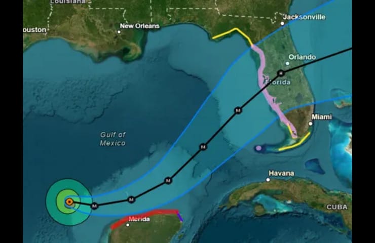
Hurricane Milton has rapidly intensified into a Category 2 storm, prompting both Hurricane and Storm Surge Watches across Florida’s Gulf Coast. As of early Monday, October 7, 2024, the hurricane was located approximately 750 miles west-southwest of Tampa, with maximum sustained winds reaching 100 mph. Meteorologists predict that Milton could strengthen to a Category 4 hurricane by Tuesday before making landfall on Wednesday evening.
Current Situation
Storm Details
- Category: Currently a Category 2 hurricane
- Location: 22.1° N, 92.6° W
- Movement: East-southeast at 8 mph
- Forecast: Expected to become a major hurricane (Category 3 or higher) by midweek.
Watches and Warnings
- Hurricane Watch: Issued for the entire western Gulf Coast of Florida from Chokoloskee northward to the Suwannee River.
- Storm Surge Watch: Extending from Flamingo to the Suwannee River, including Tampa Bay, indicating potential life-threatening flooding from rising waters.
Explore more articles on our Tech Blog
Expected Impacts
Storm Surge
Forecasters warn of a storm surge that could reach between 8 to 12 feet, particularly in the Tampa Bay area. This surge poses a significant risk of flooding, especially in low-lying coastal regions.
Wind and Rain
- Wind: Hurricane-force winds extend outward up to 20 miles from the center, with tropical-storm-force winds reaching up to 80 miles away. Winds are expected to start affecting Florida late Tuesday into Wednesday morning.
- Rainfall: Anticipated rainfall totals range from 5 to 12 inches, increasing the risk of flash flooding and river flooding across various counties in Florida.
Evacuations and Preparations
A state of emergency has been declared in 51 out of 67 counties in Florida as residents prepare for Milton’s impact. Authorities are urging individuals in vulnerable areas to finalize their hurricane preparedness plans and stay updated with local advisories.
Conclusion
As Hurricane Milton approaches, it is crucial for residents along Florida’s Gulf Coast to remain vigilant. The combination of strong winds, heavy rainfall, and life-threatening storm surges could lead to significant impacts throughout the region. Stay tuned for updates from the National Hurricane Center and local meteorological services as this situation develops.